NWP_TEAM2
URBAN HEAT ISLAND
Research 3 - Distribution
1. Cropland & Urban
Cropland
25
Urban
50
Cropland
25
Urban
25
Cropland
50
Urban
25
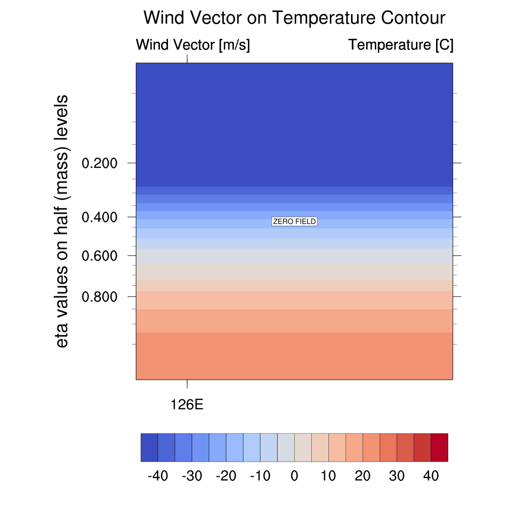
Temperature and Wind Vector


Cropland-Urban-Cropland
Urban-Cropland-Urban
Since Urban areas generally have higher temperatures than non-urban areas, the temperature at the Cropland center appears higher. The wind vector near the surface initially points towards the Urban center, shifting towards the Cropland center in the afternoon. However, at the Cropland center, the wind direction consistently diverges towards the adjacent Urban areas.
Relative Humidity

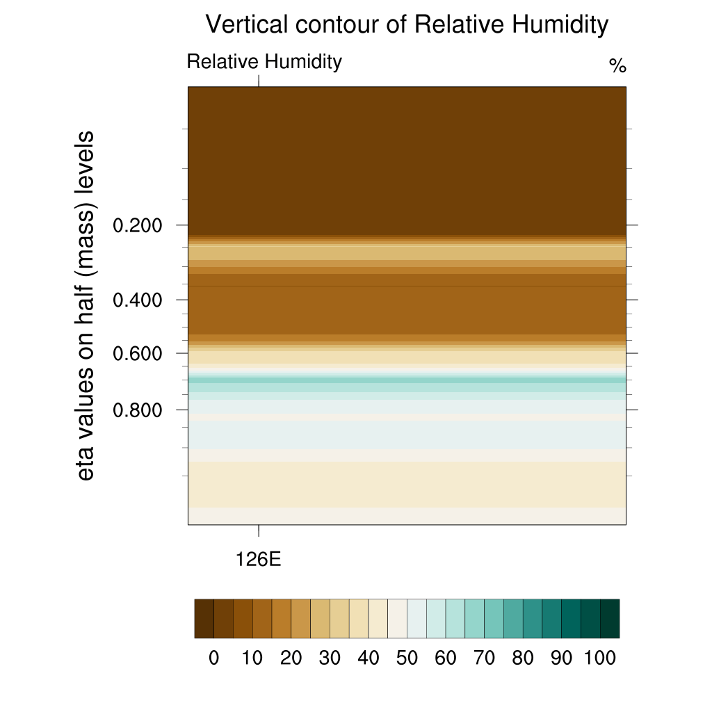
Cropland-Urban-Cropland
Urban-Cropland-Urban
Since Urban areas generally have lower relative humidity than non-urban areas, the Cropland center also exhibits relatively lower humidity levels. However, in the afternoon, higher relative humidity appears at the Cropland center.
U-wind

Cropland-Urban-Cropland
Urban-Cropland-Urban
The u-wind(zonal wind) difference between the Urban center and non-urban center is the most pronounced. The u-wind at the Urban center is relatively weaker than in other cases. Meanwhile, at the Cropland center, the u-wind is more prominent even at upper levels, diverging towards the surrounding Urban areas. The wind direction at the Cropland center initially points towards the Urban areas but reverses towards the Cropland area in the afternoon.
W-wind


Cropland-Urban-Cropland
Urban-Cropland-Urban
The w-wind is stronger at the Urban center compared to the Cropland center. Upward airflow develops over the Urban center in the morning but gradually shifts to a downward flow by the afternoon. At the Cropland center, a downward flow initially appears over the Cropland area, followed by the development of upward airflow on both sides of the Cropland, leading to w-wind formation, although its strength is weaker than at the Urban center.
2. Water Bodies & Urban
Water bodies
25
Urban
50
Water bodies
25
Urban
25
Water bodies
50
Urban
25
Temperature and Wind Vector


Water bodies-Urban-Water bodies
Urban-Water bodies-Urban
The significant temperature difference between these regions leads to a distinct temperature contrast near the surface. The temperature at the Urban center also decreases faster than at the Water bodies center, likely due to the initially large temperature difference, which diminishes the heat capacity effect of water, and the 12-hour timeframe used. Similar to Cropland, the wind direction near the Urban center initially points towards it but shifts direction in the afternoon. At the Water bodies center, the wind direction consistently points towards the Urban area.
Relative Humidity


Water bodies-Urban-Water bodies
Urban-Water bodies-Urban
The high relative humidity over Water bodies leads to the most noticeable contrast between the Urban and non-urban centers. Initially, the relative humidity at the Water bodies center is lower due to the influence of nearby Urban areas, but in the afternoon, the relative humidity near the surface around the center of the Water bodies area gradually increases, reaching levels above 80%.
U-wind


Water bodies-Urban-Water bodies
Urban-Water bodies-Urban
The u-wind at the Urban center is stronger than at the Water bodies center, and, in fact, it is the strongest among all cases. Initially, the u-wind at both the Urban center and Water bodies center points towards the Urban area, but in the afternoon, it shifts towards the Water bodies area.
W-wind


Water bodies-Urban-Water bodies
Urban-Water bodies-Urban
As with Cropland, stronger w-wind appears at the Urban center. In the afternoon, the Urban center shifts from upward to downward flow, while the Water bodies center transitions from downward to upward flow. However, the strength remains lower at the Water bodies center.
3. Mixed Forest & Urban
Mixed Forest
25
Urban
50
Mixed Forest
25
Urban
25
Mixed Forest
50
Urban
25
Temperature and Wind Vector

Mixed Forest-Urban-Mixed Forest
Urban-Mixed Forest-Urban
The temperature difference near the surface between the Urban center and Mixed forest center resembles that seen with Cropland. The rate of temperature decrease is slightly faster at the Urban center, though the difference is minimal. The surface-level wind is more irregular than in other cases, with a predominance of horizontal u-wind.
Relative Humidity


Mixed Forest-Urban-Mixed Forest
Urban-Mixed Forest-Urban
The pattern of relative humidity resembles that of Cropland, although slightly higher relative humidity persists in the afternoon.
U-wind


Mixed Forest-Urban-Mixed Forest
Urban-Mixed Forest-Urban
The wind direction similarly reverses towards the non-urban area in the afternoon. This case shows the smallest difference in u-wind between the Urban center and the non-urban center.
W-wind


Mixed Forest-Urban-Mixed Forest
Urban-Mixed Forest-Urban
Stronger w-wind also develops at the Urban center, similar to other cases. A strong but brief upward flow forms over the Urban center in the morning, which transitions to a downward flow in the afternoon, though it is noticeably weaker than the initial upward flow. At the Mixed forest center, downward flow develops over the mixed forest area, but the overall w-wind strength decreases in the afternoon.